 |
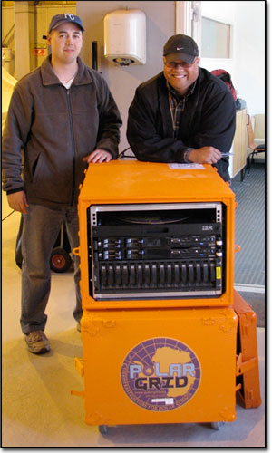
Eric Akers and Je'aime Powell with equipment |
Polar Grid July 2008 Field Season - Ilulissat, Greenland Representatives from Elizabeth City State University (ECSU) joined Polar Grid Team members from Indiana University (IU) and the University of Kansas (KU) for the 2008 Greenland Research Expedition in Ilulissat, Greenland. Dr. Eric Akers, ECSU professor and Mr. Je'aime Powell, ECSU graduate student, travelled in support of the project from the Center of Excellence in Remote Sensing Education and Research (CERSER).
There were three goals assigned to the Polar Grid project in support of the CReSIS project. Those goals were to provide backup facilities for all data collected on the CReSIS flights, provide processing facilities to test data in the field and lastly to send processed images to the University of Indiana for geographical based image feeds.
The members of the CReSIS project utilized a Twin-Otter fixed wing airplane to map the ice sheet layers. They did this with antennas attached to the wings that produced radio waves in the VHF range. They did this to attempt to map the base of the Jakobshavn Glacier. The ice sheet itself appears with layers denoting each passing year like the rings of a tree. The layers closer to the bedrock or base of the glacier are the older layers. Those closer to the surface are the newer. By mapping the total thickness of the ice sheet over a period of time, a determination of whether the ice is melting can be presented analytically.
The data from received from six antennas was recorded every 100 microseconds (10e-6 seconds). Over the course of a grid with multiple flights over thousands of kilometers, data was collected constituting hundreds of gigabytes of storage space. Previously this data was not stored in a redundant manner. In other words if a hard disk was corrupted or failed, that seasons data was lost. Through the use of a 30Tb (14 TB usable) RAID 10 storage center, any data stored was mirrored as soon as it was transferred to the cluster using an error checking copy method named “rsync”. This provided a double redundancy to critical data. A tertiary backup of all data was also accomplished through the use of 2Tb external drives, that mirrored each day individually.
The raw data received from the antennas must be filtered and placed in context through visual means. To process the large amounts of data required a rather powerful computer or cluster of computers. Polar Grid provided extended processing capabilities through the use of 8-cores @ 2.33 GHz machine with 16 GB of RAM. Combined with a
 |
Jakobshavn Glacier with radar antennas |
distributed version of Matlab many processing jobs that may have taken days on a single laptop were reduced to hours. Thereby providing scientist not in the field the ability to recommend changes to the RADAR while the season was still active. Half way through the season an additional 16 GB’s of RAM were added to the cluster for a total of 32 GB to allow even greater processing capabilities.
The final goal of the Polar Grid season was accomplished when actual field imagery was transferred to the Indiana University Community server, to provide processed data for users to view. The users were able to enter a secure web server and actually view the locations the data was collected while utilizing the embedded GPS tag. The future expansions of the “geofeed” are only beginning to present themselves for the scientist and projects of the coming years.
In conclusion all of the goals for this field season were accomplished using the Polar Grid field camp cluster. With the lessons learned and insights gained through the Ilulissat expedition, the expansion of the Polar Grid into future CReSIS missionswas solidified. The testing of the fully capable 64 node cluster is scheduled for the fall 2008 Antarctic field season.
|